ÎYÂRHE NAKODA – Did you know that before Oct. 24 you could not call 911 from a landline in Mînî Thnî?
Instead of dialling the three-digit number, those calling from a landline in the area were directed to a 10-digit number to connect to RCMP, fire and EMS in an emergency.
As of earlier this week, that’s no longer the case in the Îyârhe Nakoda First Nation community as local emergency services work toward improving response times through a 911 mapping project.
“Everybody in Mînî Thnî now has access to 911 from a landline or from a mobile phone,” said Janna Hart, Nakoda EMS manager. “No. 1 is it really does enhance the accessibility of the location information, which, in turn, facilitates a more rapid and effective response from emergency services.
“Now when somebody calls 911 from a landline or mobile phone, they’re automatically transferred to an emergency dispatcher in Calgary, and from a landline, their location information is immediately available to the dispatcher, which it wasn’t before.”
According to a 2013 report prepared for the Canadian Radio-television and Telecommunications Commission (CRTC), it was estimated 98 per cent of people in Canada have access to 911 service. Where not available, people in those areas dial a regular telephone number to reach emergency responders.
Nakoda Emergency Services, which provides protective services, fire and EMS to the community, has been working to change this, with Hart helping to lead the mapping project over the last two years.
The agency is using geographic information system (GIS) technology to collect mapping data, which is shared with emergency services so first responders can get to those in need faster using accurate location information.
Prior to the Nation using a GIS platform, answering dispatchers were unable to see where landline callers in Mînî Thnî were located. Additionally, 911 calls from a cell phone or a landline were not automatically directed to the nearest dispatch centre – Calgary – but could be directed to any dispatch in western Canada.
“So, if for whatever reason someone calling from their home phone couldn’t communicate or otherwise wasn’t able to quickly say where they are – even if they could, the dispatcher could have been anywhere in western Canada, and there’s a good possibility they might not be familiar with the geography,” said Hart.
“Now it goes straight to Calgary and those dispatchers know the Nation well and that location information auto-populates.”
In some cases, this can improve response times by 10 to 15 minutes or more if it takes a dispatcher that long to ascertain the caller’s location and then transfer the call to the appropriate dispatch centre, Hart explained.
“Ten to 15 minutes in an emergency is a long time,” she added.
A critical part of the location mapping process involved assigning alarm numbers to residences and commercial buildings, as well as naming over 200 roads in Îyârhe Nakoda First Nation to better direct first responders.
Sgt. Mike Eady with Stoney Nakoda and Kananaskis RCMP said the initiative will greatly benefit community members and emergency personnel.
“With the new 911 project in Stoney, this can only assist us and other emergency responders in having a better response time, due to having addresses mapped and available to us, rather than having to search for a residence that was not previously given an address,” he said in an email.
Eady said he could not provide number specific to Stoney Nakoda regarding average response times but said for all of Rocky View County in 2022, the time from when a 911 call was received to an RCMP member arriving on scene was about 22 minutes for calls involving in-progress incidents and/or requiring immediate police presence.
“In 2022, 52 per cent of all priority 1 and 2 calls had members on scene in 20 minutes or less, 68 per cent in 25 minutes or less, and 81 per cent in under 30 minutes,” he said.
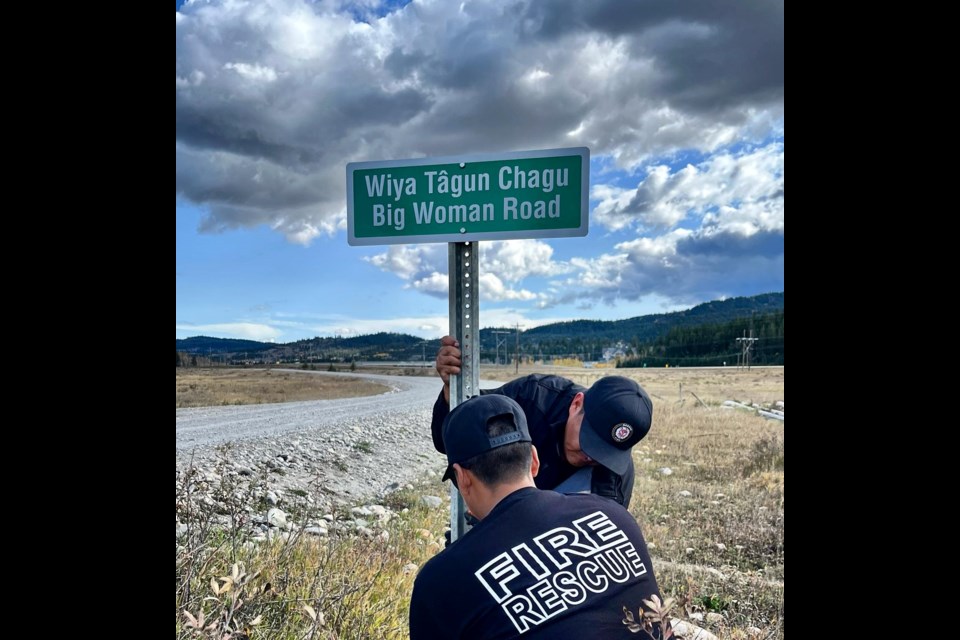
Only a few road signs have gone up thus far, said Hart, but more will be installed in the spring. The names, chosen by elders in the community, have already been logged for emergency services.
Hart noted this part of the project was “really special.”
“Local elders from the three bands (Goodstoney, Chiniki and Bearspaw) were able to name all of those roads and those road names were based on the history of the area, or some of them were named directly after an elder who had lived in the area, using the elder’s Indigenous name,” she said.
Some names include River Mouth Road, Sundance Road and Walking Buffalo Road. Signage will include the name in Stoney as well as in English and road signs will go up in the Îyârhe Nakoda communities of Big Horn and Eden Valley in spring 2024.
The Local Journalism Initiative is funded by the Government of Canada. The position covers Îyârhe (Stoney) Nakoda First Nation and Kananaskis Country.


