PERU - I had to see this place, a city in the clouds.
But first, there is Lima to see.
Did you know that this city situated on Peru’s Pacific Coast is in a desert?
The last rain fell seven years ago. It’s dusty and arid. Greenery can be seen only along the coast where plants are watered by ocean mist.
Along the green cliffs of Miraflores, hang gliders zoom overhead while surfers ply the ocean waves.
Francisco Pizarro, a Spanish conquistador, arrived here in 1532. The then enormous Inca empire, extending as far as Ecuador, Chile, Argentina and Bolivia, had been weakened by civil war.
Atahualpa, the new emperor, was forced to meet Pizarro at Cajamarca. The Incas, with their clubs and stones, were no match for Spanish guns.
Carried on a golden litter, Atahualpa proposed the most extraordinary offer in history. For his freedom, he would fill a 22 by 17-foot room with gold.
Soon precious metals flowed in from subjects all over the kingdom. However, Pizarro reneged, and Atahualpa was garroted. Peru would be a Spanish colony.
Pizarro preferred a coastal city, so on Jan. 6, 1535, Lima became the capital. Streets were organized after Roman plans. A wall was built for protection against pirates.
The City of Kings today has 11 million inhabitants, sprawling haphazardly in every direction.
Its people are a melting pot due to colonization, immigration, and indigenous Andeans streaming in from the mountains for better jobs. Though that may be $10 per day (minimum wage), they come.
It is interesting that doctors earn $4,000 per month and professors much more, at $7,000 per month. There is no welfare and at the age of 65 people can apply for a government pension of $80 per month.
Lima’s main square is the Plaza de Armas, where grand colonial buildings sit next to the Basilica of San Francisco. Here catacombs house about 70,000 bones of colonial people.
The impressive President’s Palace is next door. The guide tells his guests the president is elected every five years and voting is mandatory. Those who choose not to vote are fined $80.
Peru has had a difficult history. In the 1970s and 80s terrorist groups fought for control and inflation rose to 3,000 per cent. Eventually, civilians, secret agents and the army brought stability to Peru.
As this article is written, Peru’s current prime minister is in jail for attempting a coup.
Before leaving Lima, the group visited the best museum of pre-Columbian pottery anywhere. It’s the Museo Larco. Situated in an 18th century vice-royal residence, it is well known for its collection of 40,000 artifacts. Cusco is the next stop.
Cusco in the Andes
At an elevation of 11,150 feet, Cusco is where to acclimatize before ascending Machu Picchu.
Coca tea is available in a hotel lobby. It is supposed to prevent altitude sickness. Oxygen bottles are also sold at the front desk.
In Cusco, temples, palaces and fortresses are expertly engineered to withstand earthquakes.
The rock work, still seen on many buildings, is built in such a way that a piece of paper cannot be slipped in between the stones. The irregular pieces fit together without the use of mortar.
You can still see some of the stone walls of Koricancha, the ancient Sun Temple. These lie under the monastery of Santo Domingo.
Its ancient walls were once covered in finely crafted plates of silver and gold. No wonder the Spanish lusted to have this empire of riches.
Above the city, sits an ancient archeological site called Sacsaywaman. The enormous citadel, made of colossal boulders, was another battle site between the Incas and the Spanish. Many of the stones of this fortress complex weigh up to 300 tonnes, rising to 27 feet.
As the group leave the fortress, and the large Cristo Blanco statue overlooking the city, guests wind their way into the countryside north of Cusco.
Small statue charms sit on rooftops. A pair of bulls, anchored on the roofs, promise protection and prosperity. They cross high plateaus and mountains on their way to the Sacred Valley.
Sacred Valley
The group stops briefly at Pukapukara, a strategically placed ancient fortress, sitting at 12,00 feet above sea level. It is harder to breathe.
They cross high plateaus and mountains. In colonial times, people had to walk down to the valley once a week to pay taxes. To this day, farmers who still tend the terraced fields clinging to mountainsides walk an average of 20 kilometers a day.
Irrigated by the Urubamba River, the fertile Sacred Valley unfolds below. It is 9,000 feet above sea level and is the best route to Machu Picchu, the goal of their journey.
Near the town of Pisac, mountainsides are covered by terraces. Terrace farming was developed for producing food in the harsh Andean climate. Inca trails connect the terraces.
In Inca times, short distance relay runners ran along the trails, carrying official messages-in a language comprised of knotted strings.
Unfortunately, many of the terraces and trails have been damaged.
Before leaving Pisac, the group shops in the largest market this side of Machu Picchu.
In Lemay, a guinea pig statue welcomes them. The rodent wears ornate garments and a crown. No wonder, as these animals have been a Peruvian delicacy for thousands of years. The little pigs are often kept in the kitchen as pets and fed rich green hay.
Closer to Urubamba visitors spend a night before taking a train to Aquas Calientes, the town from which they will ascend Machu Picchu.
But first, a stop is required in Ollantaytambo to see well-preserved temples and fortress ruins.
On this site, Inca Manco, a resistance Inca fighter, faced Pizarro’s troops and won. However, this victory was the last one before Pizarro completely subdued the proud people.
Today, there is a cold wind blowing, and colourful wool scarves are available from the market situated below the ruins.
Beautiful Andean women sit on the cobblestones and weave on handheld looms. They wear a small round hat covered in flowers. Typical for this area, it’s placed jauntily on the side of the head.
On the road again, red flags on buildings signify ‘chicha’ or corn beer sales, the most common beer in Peru. Blue flags indicate three per cent beer sales.
Whichever libation you buy, it is common to spill some on the ground to honour Pachamama, Mother Goddess of the earth.
At 7:15 the next morning visitors leave the rustic and elegant Yucay Hotel and board the train for Aquas Calientes.
Situated in a deep gorge, and surrounded by steep mountains on every side, Aquas Calientes is a tourist mecca. Everyone is here to see Machu Picchu.
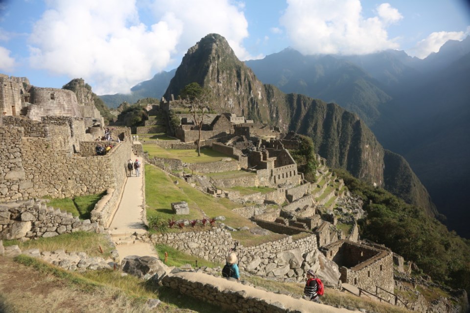
Machu Picchu
By 10 in the morning, a bus is grinding up Hiram Bigham Highway, a gravel road of switchbacks, to 7,970 feet and the entrance to famous Machu Picchu.
This world heritage site is strictly controlled. An entry pass is good for only four hours. After showing their passports and tickets, the group is split into two.
As soon as they enter the complex, it’s evident that this is an enormous city. Stone houses, steps, platforms, and terraces spread out, forming the most impressive archeological site that can be seen anywhere.
Here, high on a mountain, everything is bathed in a kind of celestial light. All around this City in the Clouds, misty mountain peaks rise, as if protecting the royal estate.
And today, visitors are fortunate no cloud forest or rain covers the site. Photographing Machu Picchu will go well.
In 1911, Hiram Bingham, an explorer and Yale historian, discovered Machu Picchu. He was looking for the legendary lost city of the Incas and found Machu Picchu instead.
In 1912 he returned to do major clearing of overgrown vegetation. He then named most of the buildings on the site, such as the Funeral Rock, Room of the Three Windows, Temple of the Sun, and the Sacred Way.
But why was Machu Picchu built?
In 1450, Emperor Pachacutec, whose statues appear in every Peruvian city, built the city as a royal estate. It took 80 years to build by some 20,000 workers.
Then 100 years later, it was mysteriously abandoned.
Spanish conquerors did not discover the site, possibly because of its remoteness and proximity to the malaria-infested Amazon.
The stones used for the fortress were quarried from the mountain on which the city stands.
Structures were built in the same Inca style as those in Cuzco. Dressed dry stone and no mortar.
Rocks were hewn to fit tightly together in the typical Inca fashion. All the doors were wider at the base than at the top. Windows were also irregularly shaped. These engineering techniques were used to withstand earthquakes.
Just like many other early temples in Mexico and Egypt, buildings were constructed in such a way that once a year, during the summer solstice, the sun would shine directly into the most sacred part of the structure.
We know that the Incas were very aware of astronomy, so buildings were sometimes placed in line with constellations. No wonder that Machu Picchu is a mecca for astrologers.
We are sure we have seen the most amazing part of Peru, but there is more to see.
Moray and Maras
In Moray, a high plateau north of Cusco, a unique depression in the landscape is filled with concentric stone terraces.
Scientists believe that this was possibly an agricultural testing station.
Due to the rock walls and its depth of 98 feet, there are microclimates at the different terrace levels. The Incas may have been using this site to study the effect of climate on crops. And that was long before there was an awareness of climate change.
A few kilometres west, in the town of Maras, evaporation salt ponds fill a steep valley bottom. A salt spring flows into each pond.
A few years ago when mountain salt was not yet popular, salt from these 5,000 ponds sold for pennies a kilo. Today the price is five times that. Not one of the families who own these ponds is ready to sell.
In Cusco we had seen alpacas paraded for tourist photos. Now we see them in their natural environment.
In the village of Chinchero, indigenous women form a weaving cooperative where they shear, spin and weave sheep and alpaca hair into lovely ponchos, sweaters and table covers. Bright Andean colours permeate the beautiful handiwork.
The women’s outfits are fascinating. Black layered wool skirts are worn over leggings. Each woman wears a blouse embroidered with her personal designs.
On top of that she wears a woollen vest, decorated with ribbons and buttons. A woollen bolero-type jacket, or a woven shawl tops the outfit.
Their hats are also interesting. The round red woollen hats protect from cold, sun and rain. Inside the top part is a secret pocket where women keep their money.
The young mother who demonstrates all aspects of the cooperative, laughs, and says that her husband does not dare touch her hat. What other secrets are concealed there? Each region in the Andes has its own hat patterns and colours.
Leaving the high plateaus, we have one more area in Peru to explore. Did you know that the headwaters of the Amazon River begin in the Andes? This writer did not.
The Amazon
There is a flight to Iquitos; an Amazon city and inaccessible by road.
At the Iquitos harbour the group settles into a long narrow covered boat, a water taxi. They motor on the Amazon River for an hour and step onto a floating platform; entrance to Ceiba Tops, a rainforest lodge where they will stay for two nights.
A plank suspended over the muddy Amazon connects them to a steep wooden sidewalk and Ceiba Tops Lodge. Generators power the lodge. Raised plank sidewalks lead to rooms. A large, open-air building invites them to lounge on the hammocks. But there is no time and much to see.
Visitors are asked to drop backpacks and begin a nature walk with Wilson, their Amazon guide. They go to see a large Ceiba tree.
Lush foliage crowds the rainforest trail. Wilson points out a poisonous frog. There is surprise at how small it is. Only two inches long.
The bright blue and orange amphibian sits on a large green leaf. This is the one used for poisonous blow darts.
An enormous 250-year-old Ceiba tree looms ahead. It’s 120 feet high, with gigantic roots fanning out from the base. It is the only Ceiba tree left in this area, thanks to Jeremy, a conservationist.
Years ago, a farmer who owned the land wanted to cut down the enormous tree for lumber. He wanted to build a house. Jeremy offered to pay the farmer his asking price of $450. The farmer gladly accepted, especially when Jeremy bought the land as well.
That is how Ceiba Lodge started: in honour of that giant tree.
In the rainforest visitors see trees whose scent repels mosquitos. One has an iodine-producing root growing on its trunk.
Walking palm trees, those with smaller trunks fanning out at the base, line the trail. Termite mounds cling high on tree trunks. Ttarantulas can be seen. Army and leaf cutter ants cover the forest floor.
Later in the day, a night walk in the forest reveals Caymans, frogs, and a bat-hunting boa constrictor.
Next day there is a boat to Yagua village. The 94-year-old chief greets visitors dressed in a grass crown and skirt. They watch villagers perform a folk dance.
A young hunter, also wearing a grass crown and skirt, shows how both men and women of the village know how to use a blow gun.
The gun is about three feet long, with a round mouthpiece at one end. The hunter must place the dart in the gun, balance it with both hands and then quickly and forcefully blow. Some members of the group try it out.
In the afternoon they are back on the river, motoring for an hour. They climb up another steep bank to get onto tuk tuks, motorcycle taxis. These will take them to the Nano River, previously known as a cocaine route.
They ride in a motorized dugout canoe to Nano Lodge. It is the starting point for a walk on the world’s second longest canopy walkway.
They hike in the jungle for 45 minutes and then climb up onto a tree platform. From there, they carefully walk on narrow, netted swinging bridges.
Each bridge section is traversed by three people at a time. Some are nervous. By the sixth bridge, they are looking down on 200 feet wide treetops. The rainforest stretches endlessly on. With the forest floor far below, it is best not to look.
There are eight more bridges to cross, and nerves curtail notions to stop to examine wildlife living in the trees. Visitors are told there are parrots, poison tree frogs, monkeys and hundreds of bird and insect species which never descend to the forest floor. They live their entire lives in the trees.
No wonder, as the Amazon is one of the most biodiverse ecosystems on earth, with more than 80,000 classified species of plants.
Another rainforest day comes to an end.
The next day is their last in Peru.
Wilson has arranged a surprise. They are going piranha fishing.
A motorized dugout canoe speeds them to a lake off the Amazon River.
They are given simple bamboo poles and beef bait.
Piranhas circle their boat and eagerly tug at the bait.
No one dares to put their fingers in the water.
Some piranhas get away but four are caught. Back at the lodge, pan fried piranhas are an appetizer for their last lunch in the Amazon.
Sadly, they leave the Amazon, and utterly amazing Peru.
They are already dreaming of returning.
Mirjam Rand is an Innisfail and area writer and photographer who was recently in Peru to see Machu Picchu, the Amazon and have pan fried piranhas.


