About 40 people attended an open house on Wednesday for the Bearberry-Red Deer River area structure plan (ASP), which is currently being updated by Mountain View County.
The meeting took place at the Bearberry Hall and included an update on the ASP process by steering committee members. The draft of the updated ASP was unveiled at the meeting.
Area structure plans are used for community planning and the development and use of land. They provide a policy framework that is coordinated with the overall goals, objectives and policies of the municipality.
The Bearberry plan is being updated to bring it into line with the county-wide municipal development plan (MDP). ASPs can be more restrictive, but not less restrictive than the MDP.
The updated Bearberry ASP area is located in the northwest corner of Mountain View County, west of the Town of Sundre.
The plan area is bound by Clearwater County, the Red Deer River, and the northern extension of Rge. Rd. 63 from the intersection of Highway 584 to the county boundary. The total plan area encompasses approximately 194.8 square kilometres (76.8 square miles).
The steering committee, which is made up of sitting MVC councillors and members of the public at large, is overseeing the ASP update.
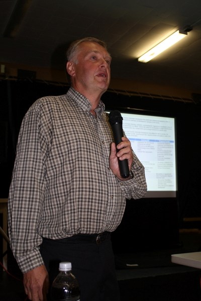
Committee chairman David Wells explained that there are several new provisions in the updated ASP.
Regarding low-density cluster, the updated ASP proposes to change the existing subdivisions for up to four residential lots and the balance as the fifth lot, to subdivisions of up to three lots and the balance as the four titled lots.
Regarding the community centre area, the updated ASP proposes to change moderate residential subdivision of up to 20 lots per quarter to low density residential of up to three lots, retaining the balances as the fourth title. Lot sizes would change from a maximum of two acres to three acres.
Regarding flood hazard and flooding, the updated ASP would create new policies to regulate and control development along the Coal Camp Road, including that “further studies shall be required as part of any subdivision or development application to determine the exact location of these lands within a site.
“When considering a proposal for redesignation, subdivision or development the county may, at its discretion, require the developer to prepare and submit a geotechnical report prepared by a qualified professional that is satisfactory to the county in form and content and in accordance with current Alberta Environment protections guidelines.”
New provisions regarding aggregate extraction include that “subdivision and development within the identified aggregate advisory areas may require a noise easement agreement to be registered on the affected lands.”
Regarding the proposed changes to the community centre, councillor and committee member Angela Aalbers said, “I see that as one of the biggest changes to the ASP. That is a very big change for you to think about.”
Guests at the meeting were given comment survey sheets seeking input on the proposed updates. Questions included: “What would you change about the land use policy areas suggested (in the ASP)?” and “What is your opinion on providing a flood risk assessment and an erosion control plan when considering applications located within the potential flood hazard/erosion areas (in the ASP)?”
Comments collected will be brought back before the committee for consideration. The survey is also available on the county's website.
A date for the next steering committee meeting had not been set at press time.


