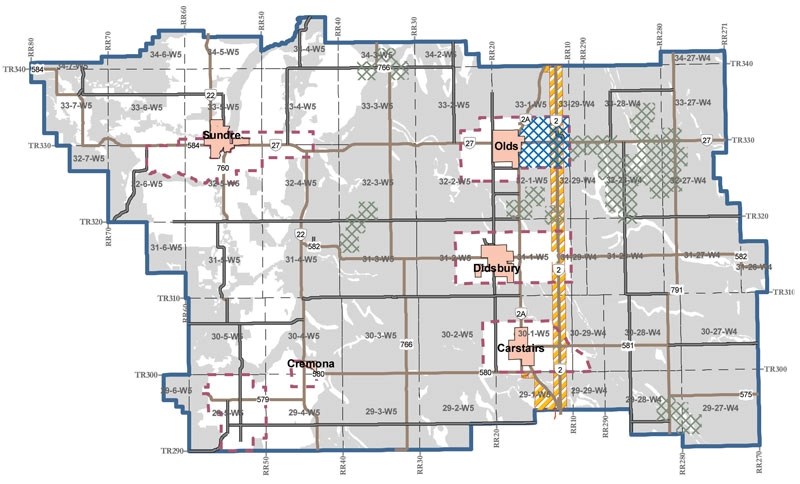
A new Municipal Development Plan for Mountain View County could be adopted as early as next month after council gave unanimous first reading to the bylaw last week.Among the latest changes, the draft sets the minimum agricultural parcel size at 40 acres (double the current 20 acres but only half of the proposed 80) and adds a clause stating that urban centres will be consulted on adjacent area structure plans.Div. 2 Coun. Patricia McKean pointed to sections in the draft plan for the Highway 2/27 Special Policy Area that set thresholds and conditions for phasing in residential development and specify that all costs for piped services will be borne by the developer or landowner.“I'm just really happy with where we got with this,” McKean said. “I think we are protecting our ratepayers and still allowing development in the county, and I'm just really happy going ahead with this,” she said.Council voted to set June 27 for the public hearing, which will open at or after 9 a.m. in the council chamber. If required, the hearing will continue on July 4. Second reading and final approval of the bylaw, as it is or with amendments, could follow the public hearing.In the works for almost 18 months, the draft MDP represents a major overhaul of the county's land-use policies that will set new limits on subdivision for most landowners. It divides the county into three land-use areas – the Agricultural Preservation Area, the Potential Multi-Lot Residential Development Area, and Concentrated Confined Feeding Operations Area – and creates an Economic Growth Corridor designation for commercial-industrial development.The Agricultural Preservation Area – shown on a conceptual map as comprising most of the lands east of Highway 22 outside town growth centres – is intended to “only allow for first parcel out residential development to ensure productive agricultural land in the county is preserved for agricultural purposes,” the draft MDP says.“Subdivision and development applications that deviate from this general policy approach within the Agricultural Preservation Area are strongly discouraged and shall require significant justification and supporting evidence.”The area's boundaries are based “as a starting point” on Canada Land Inventory class 1, 2 and 3 soils, combined with Environmentally Significant Areas mapping.The Potential Multi-Lot Residential Development Area will allow up to four titled lots per quarter (three new country-residential lots plus the balance), subject to neighbour consultation and council approval. Lot sizes must be 2-3 acres, though up to five acres will be considered.While the conceptual map includes much of the West Country within the designated area, the draft MDP says lands that are “considered high-quality forage lands shall not be subdivided for low-density residential development.”Another condition for low-density residential development is tenure of ownership, as it “should only be permitted if the landowner has held title to the quarter section for at least five years,” the draft says.The Concentrated Confined Feeding Operations Area is based on concentrations of three or more CFOs where their setbacks overlap. These areas, situated mainly south and east of Olds, “are not ideal for development, including first-parcel-out subdivision,” says the draft document.Growth Centres are identified around the towns of Olds, Didsbury, Sundre and Carstairs, the Village of Cremona and the rural neighbourhood of Water Valley. In these areas, multi-lot residential development (five lots up to a maximum of 48 lots per quarter) can be allowed if supported by an approved area structure plan. While the maximum lot size will be determined as part of the ASP process, the minimum is set at two acres.The Special Policy Area for Highway 27 also sets 48 residential lots per quarter as a maximum, but increases that number to 80 if the development is connected to municipal water and sewer systems. That maximum is one-third the allowed density approved by the previous council in the concept plan for Netook Crossing North, and developers have argued that the lower densities would make the project financially unviable.The draft specifies that the Highway 2/27 area will be redesignated to Direct Control District to “help ensure that council's direction for this Special Policy Area is followed.” The minimum lot size is set at one acre and the maximum at two acres.The draft calls for the existing 2/27 ASP and Netook North concept plan to be revised and says the “adoption of the revised area structure plan and revised concept plan by council shall occur prior to any further redesignation and subdivision approvals in the Special Policy Area.”


