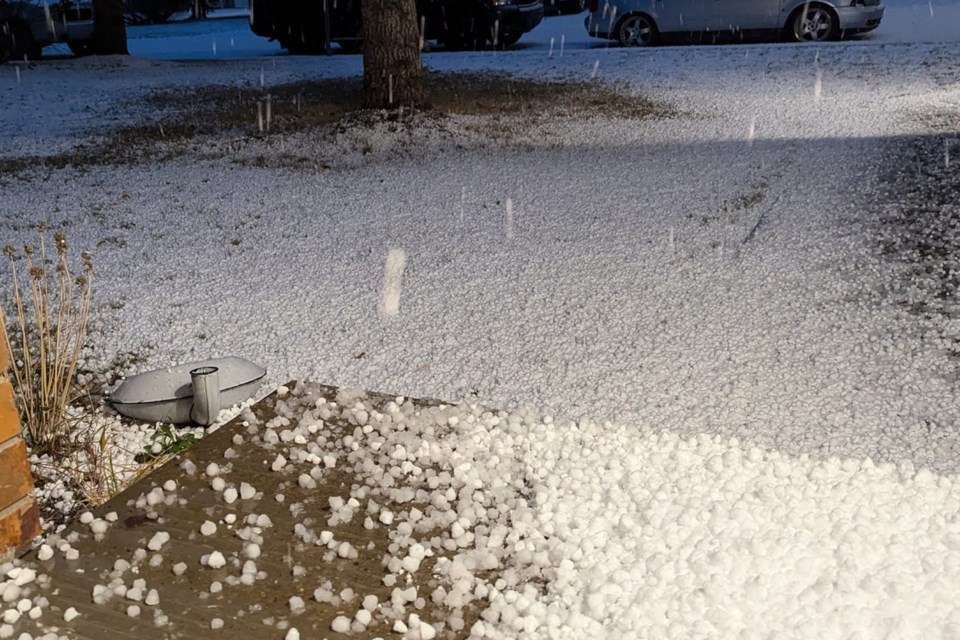
MOUNTAIN VIEW COUNTY – A severe hail-producing storm coupled with powerful thunder and lighting that swept over a relatively small swath of land from Sundre to Airdrie Monday was rare but not without precedent.
“It’s not completely unheard of to have relatively strong storms in October,” said Alysa Pederson, a warning preparedness meteorologist with Environment and Climate Change Canada (Environment Canada).
“They’ve happened in the past, it’s just not a common thing, said Pederson.
Early snowfalls are of course a fairly common occurrence as Halloween revellers prepare to don their costumes.
However, storms such as the one Mountain View County and several urban centres near it experienced on the evening of Monday, Oct. 28 shortly after 6 p.m. are certainly more rare.
WATCH: Matt Lapointe's Oct. 28 video of large hail and lightning on Highway 22 just south of Cremona:
“This being the end of October – and considering the daytime temperatures were pretty low yesterday hovering around that five degrees – it’s pretty unusual. But it’s not out of the question,” Pederson told the Albertan the following day.
“Severe thunderstorm warnings being issued in October is also relatively rare,” she added.
The thunderstorm had already largely moved through Sundre when Environment Canada issued a severe thunderstorm warning for Mountain View County and urban centres near it at 6: 51 p.m. on Oct. 28. At 6:50 p.m. the federal agency's meteorologists were tracking a severe thunderstorm capable of producing up to nickel size hail. At the time, the thunderstorm was located 10 kilometres southeast of Sundre, moving southeast at 20 kilometres an hour (km/h).
At 7:24 p.m. the agency issued an updated alert warning that the thunderstorm was located 20 kilometres west of Didsbury and was moving southeast at 20 km/h. The warning remained in effect for all of Mountain View County and the urban centres near it.
By the 8:24 p.m. alert update, the thunderstorm ws located 15 km southwest of Didsbury continuing to move southeast at 20 km/h. The warning was lifted at that time for all of Mountain View County except for the Carstairs area. The warning at that time also included parts of Rocky View County and Airdrie.
The warning was lifted for all of Mountain View County by the time the 9:17 p.m. alert update was issued. At that time, the thunderstorm was located north of Airdrie and continuing to move southeast at 20 km/h, eventually going through the city.
The last time a severe thunderstorm warning was issued in Alberta this late in the season was on Oct. 1, 2016. Just the year prior, on Oct. 3, 2015, a severe storm warning had also been issued, she said.
“So usually, it’s not quite this late in the season if we do get severe thunderstorm warnings,” she said.
As there is no observation station that was located directly under the storm’s path, Pederson said she unfortunately could not provide an estimate as to how much precipitation fell.
“I can say though, part of the reason that the severe thunderstorm warning was issued is because we got some pretty reliable reports from the forecasters that were on the desk last night of two- to three-centimetre hail,” she said.
“That’s kind of what our criteria is even mid-summer for issuing a severe thunderstorm warning, is relatively large balls of ice falling out of the sky. I’m going to call them that this time because at this time of year, it’s really hard to really understand – meteorologically – how hail could form,” she said.
“Typically, what we’ve seen and why storms are so severe and can develop significant hail within them is because there’s a lot of water vapour and a lot of moist, humid air going into a storm,” she said.
“In this case, because the temperatures within the cloud were pretty much entirely below zero, the hailstones that were formed yesterday are going to be a little bit different.”
If one were to cut in half a hail stone from the recent storm, it would have resembled something closer to a ball of snow than the icier hail produced by a summer storm, she said.
“They’re almost very large ice chunks that are almost snow,” she said. “Some of them might have been a little bit softer than others.”
And not altogether too far away from the heart of the storm, people would have largely seen some fluffy flakes.
“When the temperature is that low, a lot of the precipitation that’s going to fall out of that is also going to be snow,” she said. “Where the most intense part of that thunderstorm was, was kind of right over Sundre.”
As the storm progressed eastward “over a relatively small area” its fringes produced some precipitation much like any other thunderstorm would during the summer.
“It would be rain showers ahead of a big storm,” she said. “In this case, it was snow showers ahead of a big storm.”
Snowfall that evening was reported as far north as Rocky Mountain House and Red Deer.


